Self-Guided Walking Tour in Boston

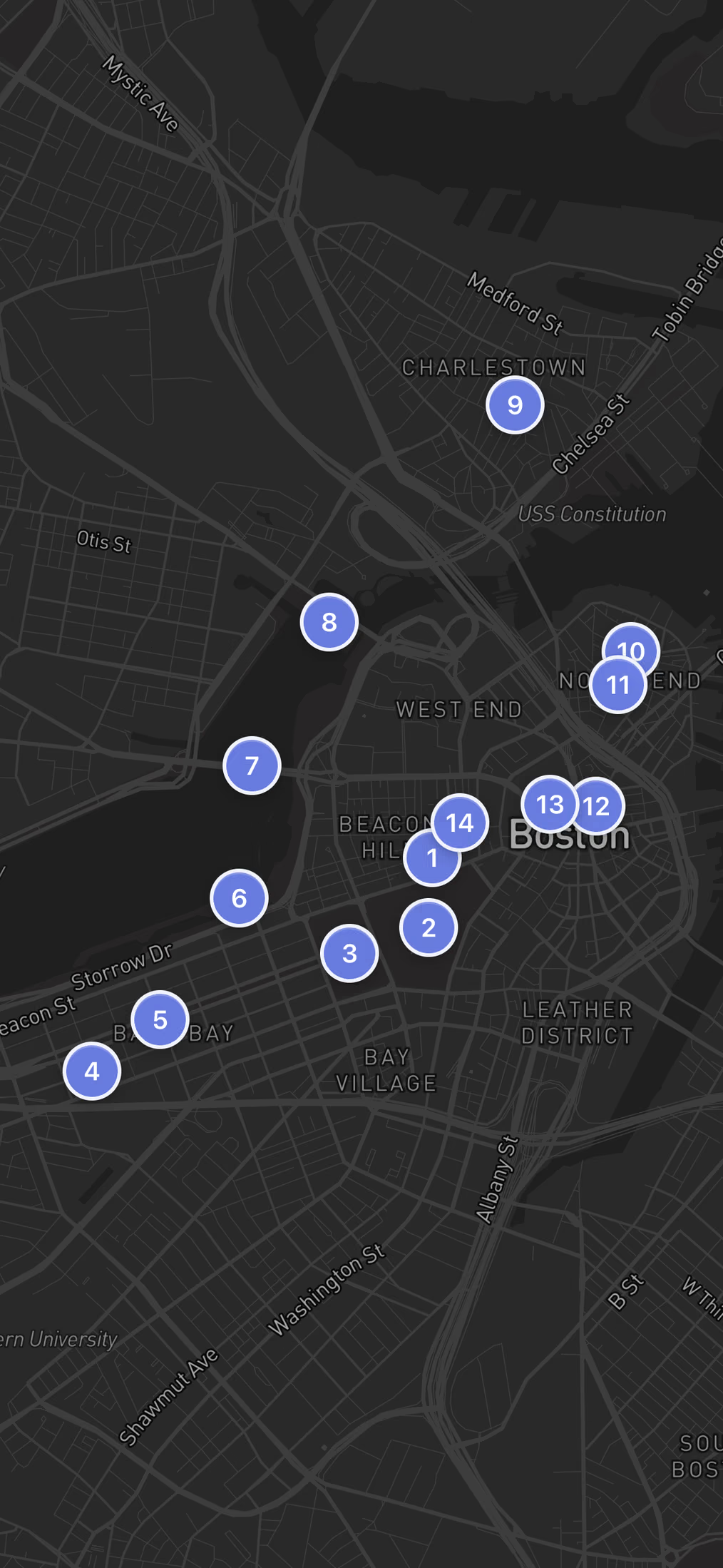
A 14-stop, 11.9 km loop that starts on the gaslit brick lanes of Beacon Hill, drops to Boston Common and the Public Garden, follows the Charles River up to Charlestown's Bunker Hill Monument, then swings back through the North End and Faneuil Hall to the gold-domed State House. This page gives you the map, every leg's walking time, real prices and hours, and shorter versions.

14 Stops11.9 km~5 hours walking4.5–5 hours with stops
What you get with AI Tourguide
Full GPS navigationInteractive AI guidePersonalized to youWorks in your browser
Try this tour with Alex

Boston Walking Tour at a Glance

This route is built for walkers who want the full sweep of Boston on foot, not a hop-on bus. Every interior along the way is optional: you can climb Bunker Hill or skip it, step inside Old North Church or admire it from the street. The outdoor line stays the same, and you set the pace, stopping wherever a neighborhood or a view holds you.

StartBeacon Hill
FinishMassachusetts State House
Route typeA near-loop, point to point on paper but ending steps from where it began. It runs south off Beacon Hill, southwest into Back Bay, then north to the river and up to Charlestown before doubling back southeast through the North End and downtown to the State House, so there is only one real out-and-back stretch across the river.
Realistic timeWalking alone is about 2.5 hours of movement across 11.9 km. Add outdoor stops and photos and you land at 4.5 to 5 hours. Going inside the Museum of Science or climbing Bunker Hill pushes it past 5.
DifficultyModerate mainly for its 11.9 km length rather than its terrain. The ground is flat for most of the walk, with a gentle rise up Beacon Hill and the optional 294-step climb inside Bunker Hill Monument. Beacon Hill and North End cobblestones are uneven and slick when wet.
Cost to followThe outdoor route is free to walk end to end, including Boston Common, the Public Garden, Faneuil Hall, and the climb up Bunker Hill Monument. Only two interiors cost money: the Museum of Science at USD 29 and stepping inside Old North Church at USD 8.
Best for:

History-minded walkers who want landmarks, river views, and Italian food packed into one long day, and who are comfortable covering nearly 12 km on mostly flat ground.

The Route

Free Walking Tour Map of Boston

14 stops11.9 kmabout 5 hours
Loading the interactive map…The complete walking route will appear here.
Want the route to guide you while you walk?Open the route with navigation and a personal guide for the history, stories and questions that matter to you.
Open route + AI guide

The 14 stops along this route

  1. Beacon Hill in Boston, stop 1 on the self-guided walking tour
    1Beacon Hill
  2. Boston Common in Boston, stop 2 on the self-guided walking tour
    2Boston Common
  3. Boston Public Garden in Boston, stop 3 on the self-guided walking tour
    3Boston Public Garden
  4. Newbury Street in Boston, stop 4 on the self-guided walking tour
    4Newbury Street
  5. Back Bay in Boston, stop 5 on the self-guided walking tour
    5Back Bay
  6. Charles River Esplanade in Boston, stop 6 on the self-guided walking tour
    6Charles River Esplanade
  7. Longfellow Bridge in Boston, stop 7 on the self-guided walking tour
    7Longfellow Bridge
  8. Museum of Science in Boston, stop 8 on the self-guided walking tour
    8Museum of Science
  9. Bunker Hill Monument in Boston, stop 9 on the self-guided walking tour
    9Bunker Hill Monument
  10. Old North Church in Boston, stop 10 on the self-guided walking tour
    10Old North Church
  11. North End in Boston, stop 11 on the self-guided walking tour
    11North End
  12. Faneuil Hall in Boston, stop 12 on the self-guided walking tour
    12Faneuil Hall
  13. Boston Public Library in Boston, stop 13 on the self-guided walking tour
    13Boston Public Library
  14. Massachusetts State House in Boston, stop 14 on the self-guided walking tour
    14Massachusetts State House
  15. That's the complete route.

    If you want more than the map and text, add live navigation and a conversational AI guide while you walk.

    Open route + AI guide
    You made it
Stop 1 of 14
Swipe →

Your Boston Walking Tour, Stop by Stop

  1. 1

    Beacon Hill

    Beacon Hill in Boston, stop 1 on the self-guided walking tour

    The tour starts in one of Boston's most photogenic neighborhoods, a grid of 19th-century brick rowhouses climbing a gentle slope above the Common. Some of the windows on the oldest homes glow purple, a side effect of manganese oxide in glass imported between 1818 and 1824 that reacted with decades of sunlight. Acorn Street, a narrow cobblestone lane often called the most photographed street in America, is tucked behind Chestnut Street and easy to miss if you are not looking. Start your walk on Charles Street at the base of the hill and work upward. The gaslit lamps, iron railings, and window boxes full of flowers make this neighborhood feel frozen in the Federal period.

  2. 2

    Boston Common

    Boston Common in Boston, stop 2 on the self-guided walking tour

    Founded in 1634, this 50-acre green space is the oldest city park in the United States. British troops camped here from 1775 to 1776. The Central Burying Ground on the Boylston Street side dates to 1756 and holds the graves of artist Gilbert Stuart and composer William Billings. Entry is free, and the park is open daily from 6:00 AM to 11:30 PM. The Frog Pond at the center transforms into a wading pool in summer and an ice rink in winter. Walk the diagonal path from the Park Street corner toward the Public Garden, passing the bronze relief of Colonel Robert Gould Shaw and the 54th Massachusetts Infantry, the first Black regiment in the Civil War.

    Hours
    Daily: 6:00 AM – 11:30 PM
    Price
    FREE
  3. 3

    Boston Public Garden

    Boston Public Garden in Boston, stop 3 on the self-guided walking tour

    Established in 1837 as the first public botanical garden in the United States, this 24-acre park sits directly west of the Common but feels like a different world. Over 80 species of plants surround a central lagoon where the famous Swan Boats have operated every season since 1877. The bronze "Make Way for Ducklings" sculptures near the Charles Street entrance are based on Robert McCloskey's 1941 children's book and are one of Boston's most beloved landmarks. Cross the ornamental suspension bridge at the center of the lagoon for the best vantage point: the Back Bay skyline reflected in the water, framed by weeping willows.

    Hours
    Always open
    Price
    Free
  4. 4

    Newbury Street

    Newbury Street in Boston, stop 4 on the self-guided walking tour

    This eight-block shopping street spans roughly one mile through the Back Bay and was originally part of a tidal flat filled during the late 19th century. Most of the brownstones lining the street were originally private homes before being converted to boutiques, galleries, and restaurants. The character shifts block by block: the Arlington Street end is high-end luxury, while the Massachusetts Avenue end has more independent shops, record stores, and casual cafes. Sidewalk dining fills the stoops in warm weather. Walk the full length for the architectural rhythm of matching bay windows and mansard roofs, then cut north toward the river.

    Price
    Free
  5. 5

    Back Bay

    Back Bay in Boston, stop 5 on the self-guided walking tour

    The neighborhood surrounding Newbury Street sits on land reclaimed from the Charles River, supported by approximately 6,000 wooden piles driven into the mud. These timber foundations must remain submerged in groundwater to prevent rot, and Boston still monitors water levels beneath the streets. Copley Square anchors the district with two architectural heavyweights facing each other: H.H. Richardson's Romanesque Trinity Church (1877) and the sleek glass facade of the John Hancock Tower. The contrast is intentional and spectacular. Walk through Copley Square to appreciate both, then continue north along Dartmouth Street toward the river.

    Hours
    Open 24/7
    Price
    Free
  6. 6

    Charles River Esplanade

    Charles River Esplanade in Boston, stop 6 on the self-guided walking tour

    This three-mile riverside park stretches along the south bank of the Charles and gives you the best open views of the Cambridge skyline across the water. The Hatch Shell, a performance venue built in 1940, hosts the annual Boston Pops Fourth of July concert that draws half a million people. The park was constructed on land created during the 1910 Charles River Dam project. On any warm day you will see runners on the path, sailboats from the nearby Community Boating center, and kayakers under the bridges. Walk east along the waterfront path toward the Longfellow Bridge, staying close to the river for the full panorama.

    Hours
    Always open
    Price
    Free
  7. 7

    Longfellow Bridge

    Longfellow Bridge in Boston, stop 7 on the self-guided walking tour

    Formally known as the Longfellow Bridge, this 1,767-foot span connects Boston to Cambridge and features four central granite towers nicknamed the "salt and pepper shakers" for their shape. The towers include carvings of Viking ships and Norse motifs, a nod to the (debunked) theory that Vikings sailed up the Charles River. The bridge is open 24/7 and free to cross. Walk halfway across for one of the best skyline views in the city: the gold dome of the State House, the Prudential Tower, and the Zakim Bridge are all visible. On the Cambridge side, MIT's campus stretches along Memorial Drive.

    Hours
    Open 24/7
    Price
    Free
    Website
    nps.gov ↗
  8. 8

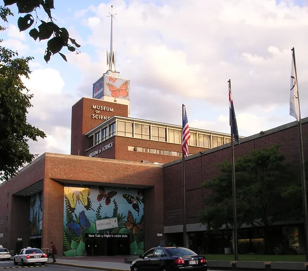
    Museum of Science

    Museum of Science in Boston, stop 8 on the self-guided walking tour

    Sitting on a dam between the Charles River Basin and Boston Harbor, the Museum of Science houses the world's largest air-insulated Van de Graaff generator. The 40-foot-tall machine can produce 5 million volts of electricity and was originally used for particle physics research before being donated to the museum. The museum is open daily from 9:00 AM to 5:00 PM. Even if you do not go inside, the exterior plaza on the dam offers a panoramic view up and down the river. From here, the Freedom Trail markers begin appearing on the sidewalk, guiding you northeast into Charlestown.

    Hours
    Daily: 9:00 AM – 5:00 PM
    Price
    USD 29
    Website
    mos.org ↗
  9. 9

    Bunker Hill Monument

    Bunker Hill Monument in Boston, stop 9 on the self-guided walking tour

    This 221-foot granite obelisk commemorates the 1775 battle that proved the Continental Army could stand against British regulars. Despite the name, the monument actually stands on Breed's Hill, where the battle truly took place. Climbing the 294 steps to the observation deck is free. The monument is open Wednesday through Sunday from 1:00 to 4:00 PM (closed Monday and Tuesday). The view from the top stretches across Boston Harbor, the Zakim Bridge, and the downtown skyline. The surrounding Charlestown neighborhood is quiet and residential, a striking contrast to the tourist density you will find on the Freedom Trail.

    Hours
    Mon-Tue: Closed | Wed-Sun: 1:00 – 4:00 PM
    Price
    FREE
    Website
    nps.gov ↗
  10. 10

    Old North Church

    Old North Church in Boston, stop 10 on the self-guided walking tour

    Built in 1723, this is the oldest surviving church building in Boston. On April 18, 1775, sexton Robert Newman climbed the 191-foot steeple and hung two lanterns to signal that British troops were crossing the Charles River by boat rather than marching by land. That signal launched Paul Revere's midnight ride. The church's white box pews, brass chandeliers, and original clock from 1726 remain intact. The narrow streets surrounding the church are the heart of Boston's North End, the oldest residential neighborhood in the city. Stop at one of the bakeries on Salem Street for an espresso before continuing south.

  11. 11

    North End

    North End in Boston, stop 11 on the self-guided walking tour

    Boston's oldest residential neighborhood covers only 0.36 square miles but packs in more than 80 Italian restaurants, bakeries, and cafes. Settled in the 1630s, this area holds the Paul Revere House, built around 1680 and the oldest surviving structure in downtown Boston. Hanover Street is the main artery, lined with trattorias where the smell of fresh pasta and espresso spills onto the sidewalk. The annual Feast of the Saints festivals in summer take over entire blocks with food vendors and live music. Walk down narrow side streets like North Square and Prince Street for a quieter, more residential feel.

    Price
    Free
  12. 12

    Faneuil Hall

    Faneuil Hall in Boston, stop 12 on the self-guided walking tour

    Built in 1742, this meeting hall earned its nickname "the Cradle of Liberty" because Samuel Adams and other revolutionaries debated independence here. Look up at the roof: the gilded copper grasshopper weathervane contains a time capsule in its belly. During the Revolutionary War, the grasshopper was used as a secret password to identify American patriots. Entry to the hall is free, and it is open Monday through Saturday from 10:00 AM to 9:00 PM and Sunday from 11:00 AM to 7:00 PM. The adjacent Quincy Market building (1826) is a long granite hall filled with food stalls selling New England clam chowder, lobster rolls, and oysters.

    Hours
    Mon-Sat: 10:00 AM – 9:00 PM | Sun: 11:00 AM – 7:00 PM
    Price
    FREE
  13. 13

    Boston Public Library

    Boston Public Library in Boston, stop 13 on the self-guided walking tour

    The McKim Building opened in 1895 as the first large free municipal library in the United States and currently holds 24 million items. The central courtyard, modeled after the 16th-century Palazzo della Cancelleria in Rome, is one of the most peaceful spots in the city. Upstairs, the Bates Hall reading room stretches 218 feet under a barrel-vaulted ceiling and makes even checking your phone feel like a scholarly act. The building is open Monday through Thursday 9:00 AM to 8:00 PM, Friday and Saturday 9:00 AM to 5:00 PM, and Sunday 11:00 AM to 5:00 PM. The murals by John Singer Sargent on the third floor took him 29 years to complete.

    Hours
    Mon-Thu: 9:00 AM – 8:00 PM | Fri-Sat: 9:00 AM – 5:00 PM | Sun: 11:00 AM – 5:00 PM
    Price
    Free
    Website
    bpl.org ↗
  14. 14

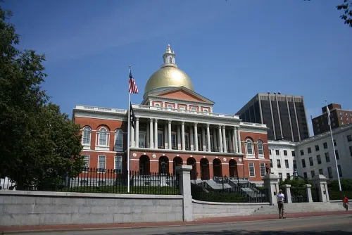
    Massachusetts State House

    Massachusetts State House in Boston, stop 14 on the self-guided walking tour

    The tour ends where Boston's political power has centered since 1798. The 23-karat gold-leafed dome was originally covered in copper by Paul Revere's company, then gilded in 1874. Inside the House of Representatives chamber, a carved wooden cod has hung since 1784 as a symbol of the fishing industry that built the colony's economy. The cod was once "kidnapped" by Harvard students in 1933 and missing for days before being recovered. From the State House steps, you look down over Boston Common where the tour began, with the full sweep of the Freedom Trail laid out below you.

    Hours
    Mon-Fri: 9:00 AM – 5:00 PM | Sat-Sun: Closed
    Price
    Free

How Long Does This Walking Tour Really Take?

Plan on 4.5 to 5 hours at a relaxed pace with photo stops and a short break. The pure walking time across 11.9 km is roughly 2.5 hours; the rest is the 14 stops. Add about 30 minutes if you climb Bunker Hill Monument or settle in for an espresso in the North End.

Allow 4.5 to 5 hours at a relaxed pace with photo stops and a short break. Add 30 minutes if you climb Bunker Hill Monument or linger in the North End for an espresso. The route is mostly flat with only gentle inclines at Beacon Hill and the Bunker Hill climb.

Full Route, Shorter Walk or Two-Day Version?

The full walk is one long, satisfying arc, but it is nearly 12 km and the river crossing to Charlestown is the least central stretch. Here are three ways to run it depending on your time and legs.

The Short Version

Skip the Charlestown crossing

Stops 1–7, then 10–14, about 8 km and 3–3.5 hours

Cut the two longest legs by walking the Longfellow Bridge for the view (stop 7), then instead of continuing to the Museum of Science and Bunker Hill, hop the MBTA Green Line or a short ride back downtown and rejoin at Old North Church for the North End, Faneuil Hall and the finish.

The Two-Day Split

Parks and river one day, revolution the next

Day 1: stops 1–8. Day 2: stops 9–14, each half 2–2.5 hours

Break at the Museum of Science. Day one covers Beacon Hill, the Common, the Public Garden, Back Bay and the Charles River Esplanade at an easy stroll. Day two starts fresh at Bunker Hill, then works back through the North End, Faneuil Hall and the library to the State House.

You can walk it in reverse from the Massachusetts State House, but the given direction is better: you tackle the long river-and-Charlestown stretch on fresh legs early, then finish downtown among the North End and Faneuil Hall where food and stops come thick and fast, ending back up on Beacon Hill where you started.

Is This Boston Walking Tour Right for You?

This is a long, flat, history-dense walk that rewards stamina more than fitness. Here is who it suits and how to bend it to your day.

A good fit if you…

  • History travelers who want the Freedom Trail landmarks plus the parks and river in one continuous route
  • Walkers comfortable covering nearly 12 km over a half day on mostly level ground
  • Anyone who likes to eat as they go, with the North End's Italian restaurants near the end of the loop
  • Photographers drawn to Beacon Hill's cobblestones, the Public Garden lagoon and the skyline from the Longfellow Bridge

Adapt the route if you…

  • Short on time: run the 8 km short version and skip the Charlestown crossing to Bunker Hill
  • Traveling with a stroller: the parks and Esplanade are paved and flat, but skip the Bunker Hill climb, which has no elevator
  • Walking in winter: layer up for the exposed Esplanade and bridge, and use Faneuil Hall and the library as warm indoor breaks
  • Wanting museums: budget extra hours and USD 29 for the Museum of Science, which opens daily 9:00 AM to 5:00 PM

Tickets & Skip-the-Line in Boston

Almost every stop on this walk is free and outdoors, so there is very little to book. Only two interiors charge admission, and a couple of stops keep narrow hours worth planning around.

Museum of ScienceAdmission is USD 29. Open daily 9:00 AM to 5:00 PM. Buying a timed ticket online ahead of a busy day saves standing in the lobby line. official ticket site ↗
Old North ChurchThe grounds and exterior are free, but stepping inside the 1723 church costs USD 8. Open Tue to Sat 10:00 AM to 5:00 PM and Sun 11:00 AM to 12:00 PM then 12:30 to 5:00 PM, closed Monday.
Bunker Hill MonumentFree to enter and climb the 294 steps, but the hours are tight: Wed to Sun 1:00 to 4:00 PM, closed Monday and Tuesday. Time your walk to arrive in that window. official ticket site ↗
Faneuil HallFree to enter. Open Mon to Sat 10:00 AM to 9:00 PM and Sun 11:00 AM to 7:00 PM, with the adjacent Quincy Market food stalls alongside. official ticket site ↗
Boston Public LibraryFree to walk in. Open Mon to Thu 9:00 AM to 8:00 PM, Fri and Sat 9:00 AM to 5:00 PM, Sun 11:00 AM to 5:00 PM. The Bates Hall reading room and courtyard are the highlights. official ticket site ↗
Massachusetts State HouseFree to visit. Open Mon to Fri 9:00 AM to 5:00 PM, closed weekends, so plan a weekday if you want to go inside. official ticket site ↗
Everything elseBeacon Hill, Boston Common, the Public Garden, Newbury Street, Back Bay, the Charles River Esplanade, the Longfellow Bridge and the North End are all free, open public spaces with nothing to book.
Optional upgrade
+10
The same 14-stop route,
now with navigation and a guide.
Optional AI experience

You already have the route.
The AI guide brings it to life.

Standing on the gaslit streets of Beacon Hill or out on Boston Common right now? Open AI Tourguide in your browser, no app and no download, and a voice guide walks the whole route with you, greeting you, telling the story along the way and asking what you want to see so it tailors the rest of the day. A real conversation built into the walk, not a recorded narration. Start with 100 free credits.

Livenavigation13languagesAnyquestionYourinterests
Open this route with the AI guide

Try it in your browser · No app or download required

Tips for Walking in Boston

  • Start by 9:00 AM to reach Bunker Hill Monument by early afternoon when it opens. The Wednesday through Sunday, 1:00 to 4:00 PM window is narrow.
  • Wear comfortable walking shoes with good grip. The cobblestones on Beacon Hill and in the North End are uneven and slippery when wet.
  • The North End is the best place to eat on this route. Mike's Pastry and Modern Pastry on Hanover Street both serve excellent cannoli, but the line at Mike's is usually longer.
  • The MBTA Green Line can shortcut you between Back Bay (Copley station) and the Museum of Science (Science Park station) if you want to trim the distance.
  • Bring water. Once you leave the Esplanade and cross into Charlestown, there are few shops or water fountains until you reach the North End.

Why Walk This Route?

This walking tour covers 14 stops across 11.9 km through Boston, taking roughly 4.5 to 5 hours at a comfortable pace with stops. You begin on the gaslit streets of Beacon Hill, cross through America's oldest public park and its botanical garden, then follow the Charles River north to Charlestown's Bunker Hill Monument before doubling back through the North End's Italian quarter and the civic landmarks around Faneuil Hall. The route finishes at the gold-domed Massachusetts State House on the hill where it started. Most stops on this walk are free, including Boston Common, Faneuil Hall, Bunker Hill Monument, and Old North Church. The longer distance is manageable because the terrain is mostly flat and the sights come in quick succession.

Common Questions

Can I do this tour in winter?

Yes, but layer up. The Charles River Esplanade and Cambridge Bridge are exposed to wind, and Bunker Hill Monument's 294 steps are inside an unheated granite tower. The indoor stops like Faneuil Hall and Boston Public Library provide warm breaks along the way. Daylight is shorter, so start by 9:00 AM.

Is this route stroller-friendly?

Mostly yes. The Esplanade, Common, and Public Garden are paved and flat. The cobblestones on Beacon Hill and in the North End are bumpy but manageable. Bunker Hill Monument has no elevator, so you would need to skip the climb. The rest of the route stays on sidewalks.

Where can I get lunch along the route?

The North End (stops 10 and 11) is the obvious choice, with dozens of Italian restaurants on Hanover Street. For something quicker, Quincy Market next to Faneuil Hall has food stalls selling clam chowder and lobster rolls. On Newbury Street (stop 4), sidewalk cafes serve salads and sandwiches.

Take this route with you

Open this exact tour with navigation and your personal AI guide.

Start GPS Navigation + AI Guide
AI Tourguide
Researched and curated by the AI Tourguide teamWe plan and quality-check every route, then research and verify the opening hours, prices, and practical tips for each stop along it.
▶ Open route with AI guideNavigation, stories and your questions