
Self-Guided Walking Tour in Otavalo

A 4-stop, roughly 3 km walk from Plaza de los Ponchos, the Indigenous craft market, through the church and central plaza to El Lechero, the sacred hilltop tree above Lago San Pablo. The page gives you the map, the walking time for every leg, real hours, and a shorter half-day option.

4 Stops3.1 km~1 hours walking2.5–3 hours with stops
What you get with AI Tourguide
Full GPS navigationInteractive AI guidePersonalized to youWorks in your browser
Try this tour with Alex

Otavalo Walking Tour at a Glance

This route is built for anyone who wants Otavalo beyond the sweater stalls: the market, the church, the plaza where the town actually lives, and the climb everyone tells you to make. Every interior here is free, and every stop is optional. You set the pace, linger at the market as long as the haggling takes, and stop when you want. Nobody is rushing you between sites.

StartPlaza de los Ponchos
FinishEl Lechero
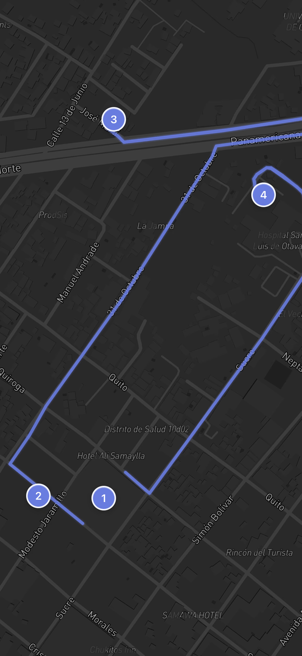
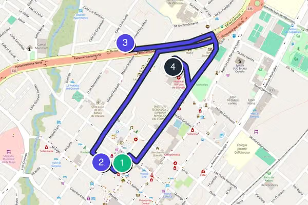
Route typeA near-straight point-to-point line running roughly north then southeast, from the market up to the ridge. No loop and no backtracking, though the only way down from El Lechero is back along the same road into town.
Realistic timeThe walking itself is only about 30 minutes spread across three legs. With a slow loop of the market, a rest on the plaza, and the uphill haul, budget 2.5 to 3 hours for the full day.
DifficultyAbout 3 km total. The town center is flat with cobbles and uneven sidewalks, but the final leg to El Lechero is a steep dirt-and-stone road. At roughly 2,500 meters the thin air makes that climb harder than the distance suggests.
Cost to followThe whole outdoor route is free to follow. The market, Santuario de San Luis, Parque Bolívar, and the El Lechero viewpoint all cost nothing to enter. Your only spending is whatever you haggle for at the stalls or a coffee on the plaza.
Best for:

Travelers who want the famous market and the hilltop view in one self-paced morning, and who don't mind one genuine uphill push at altitude to earn the payoff at the end.

The Route

Free Walking Tour Map of Otavalo

4 stops3.1 kmabout 1 hours
Loading the interactive map…The complete walking route will appear here.
Want the route to guide you while you walk?Open the route with navigation and a personal guide for the history, stories and questions that matter to you.
Open route + AI guide

The 4 stops along this route

  1. Missing required field: waypoints[0].image
    1Plaza de los Ponchos
  2. Missing required field: waypoints[1].image
    2Santuario de San Luis
  3. Missing required field: waypoints[2].image
    3Parque Bolívar
  4. Missing required field: waypoints[3].image
    4El Lechero
  5. That's the complete route.

    If you want more than the map and text, add live navigation and a conversational AI guide while you walk.

    Open route + AI guide
    You made it
Stop 1 of 4
Swipe →

Your Otavalo Walking Tour, Stop by Stop

  1. 1

    Plaza de los Ponchos

    Missing required field: waypoints[0].image

    The noise reaches you before the stalls do. Vendors call out, radios play, and the whole square is a grid of canopies stacked with woven blankets, alpaca sweaters, beaded jewelry, and the striped ponchos the place is named for. This is one of South America's largest Indigenous markets, and Saturday is the big day, when the stalls spill blocks beyond the plaza itself. Come early. It runs daily from 7 in the morning to 6 in the evening, and the light before 10am is when photos work and the crowds are still manageable. Entry is free, the haggling is expected, and a polite counteroffer of about half the asking price is the local rhythm. Do not buy the first thing you see. The same scarf sits at twenty stalls. Walk it once before you spend. When you are done, head a few blocks south toward the church tower you can see over the rooftops.

  2. 2

    Santuario de San Luis

    Missing required field: waypoints[1].image

    After the racket of the market, the church is a hard reset. This is the town's main sanctuary, fronting the central square, and stepping inside drops the volume to near silence. It is a working parish, not a tourist site, so treat it that way. The doors are open during daylight hours, and Sunday Mass runs at 9 in the morning and 7 in the evening, when the place fills with locals and you should hang back rather than wander the aisles. Entry is free. There is no ticket, no line, and ten minutes inside is plenty unless a service is on. The real value here is the breather and the cool air before you keep moving. Step back out the front, and the open green space ahead of you is the next stop.

  3. 3

    Parque Bolívar

    Missing required field: waypoints[2].image

    This is where Otavalo stops performing for tourists and just lives. The central plaza is the civic heart of town, a block of trees, benches, and a statue, ringed by the municipal buildings and a few cafes. Old men read newspapers, kids chase pigeons, and shoeshine stands work the corners. It is open from 7 in the morning until just after 9 at night, it costs nothing, and it is the best place on this walk to sit for fifteen minutes and watch the town go by. Grab a coffee from one of the cafes on the edge and take a bench. This is also your last flat ground and your last easy bathroom and water stop before the climb, so use it. When you are ready, head east and start uphill. The road climbs out of town toward a single tree on the ridge, and that tree is where you are going.

  4. 4

    El Lechero

    Missing required field: waypoints[3].image

    The last stretch earns the view. It is roughly 1.5 kilometers uphill out of town, and at this altitude the climb will have you stopping to breathe. At the top stands a single old tree, El Lechero, considered sacred in local Kichwa tradition, alone on the ridge with the whole valley laid out below. In front of you is Lago San Pablo, the largest lake in Imbabura province at 583 hectares, sitting at the foot of the Imbabura volcano. The lake was formed by water draining from the Peguche waterfall, and on a clear morning you can trace the totora reeds along its edges. The viewpoint is open around the clock and free. Come in the morning before the clouds settle over the peaks, because by afternoon the volcano often vanishes into haze. This is the end of the walk and the reason most people remember Otavalo. Sit, catch your breath, and stay a while before heading back down the same road into town.

How Long Does This Walking Tour Really Take?

Budget 2.5 to 3 hours, and most of that is two places. Plaza de los Ponchos rewards a slow loop, so 45 minutes to an hour there is realistic if you actually want to buy. The church and plaza are 10 to 15 minutes each. The climb to El Lechero is about 30 minutes uphill at altitude, plus time to linger at the top.

Budget two and a half to three hours for the full walk, and most of that is two places. Plan to spend the longest at Plaza de los Ponchos, because the market rewards a slow loop and the haggling takes time. Forty-five minutes to an hour there is realistic if you actually want to buy something. The church and the plaza are quick, ten to fifteen minutes each, though Parque Bolívar is the right place to stop and rest properly before the climb.

The climb to El Lechero is the part people underestimate. It is about 30 minutes uphill at altitude, so add buffer for stopping to breathe, and plan to linger at the top once you make it. The natural break point is Parque Bolívar: grab a coffee at one of the cafes on the edge of the plaza, take a bench under the trees, and rest your legs before the only hard part of the day. Carry water for the climb, because there is nothing to buy once you leave town.

Full Route, Shorter Walk or Two-Day Version?

The full walk is four stops in one clean line, but the last leg is the hard one and the middle leg is the longest. Here are three ways to run it depending on how much climbing you're up for and how much of a morning you have.

The Short Version

Town Center Without the Climb

Stops 1 to 3, Plaza de los Ponchos to Parque Bolívar, about 1.4 km and 1.5 to 2 hours

Skip the steep final leg to El Lechero and finish on the plaza. You still get the market, the church next door, and the civic heart of town, with almost no elevation and no need for serious shoes. This is the version for anyone feeling the altitude or short on a morning, and you keep every stop that sits on flat ground.

The Easier Split

Market Morning, Ridge Later

Stops 1 to 3 first, then stop 4 as a separate outing, split at Parque Bolívar

Do the flat town-center stops on your own two feet in the morning, rest on the plaza, then tackle the 1.5 km climb to El Lechero as a fresh push once you've caught your breath, or on a second visit. Parque Bolívar is the natural break point: it's your last flat ground, coffee, and water before the only hard part of the day.

You can walk it backwards, starting at El Lechero and ending at the market, but the forward direction is the one to take. Going this way you catch Plaza de los Ponchos in the thin morning crowds and best light, and you climb to the ridge before the afternoon clouds settle over the Imbabura volcano. Reverse it and you arrive at the market hot and tired, after the good stalls have packed up.

Is This Otavalo Walking Tour Right for You?

This is a short walk with one real climb, so who it suits comes down to how you feel about altitude and a steep dirt road at the end. Here's how to read it for your own day.

A good fit if you…

  • Market lovers who want time to browse and haggle at one of South America's largest Indigenous markets
  • Travelers who like a free, self-paced route with no group and no booking
  • Anyone chasing the classic El Lechero view of Lago San Pablo and the Imbabura volcano
  • Photographers who can start early, since the clearest shots of the peak are before noon

Adapt the route if you…

  • You're feeling the 2,500-meter altitude: stop at Parque Bolívar and skip the climb to El Lechero
  • It's raining: the market and church stay doable, but save the dirt climb for a clear window
  • You only have an hour or two: run the short version, stops 1 to 3, and stay on flat ground
  • You want the wider valley too: this walk covers the town, so pair it with a vehicle day for the lake shore and Peguche waterfall

Tickets & Skip-the-Line in Otavalo

There are no tickets to buy on this walk. Every stop is a free open-air space or a working parish, so there's nothing to book ahead. The notes below are just the practical hours and etiquette worth knowing before you go.

Plaza de los PonchosFree to enter, no ticket. Open daily 7:00 AM to 6:00 PM, and Saturday is the biggest market day. Come before 10am for the best light and thinner crowds. Haggling is expected: a polite counteroffer of about half the asking price is the local rhythm.
Santuario de San LuisFree, no ticket. This is a working parish open during daylight hours, with Sunday Mass at 9:00 AM and 7:00 PM, when locals fill the pews and you should hang back rather than wander. Ten minutes inside is plenty unless a service is on. Confirm current hours with the parish. official ticket site ↗
Everything elseParque Bolívar and El Lechero are both free open-air spaces with no ticket desk. The plaza is open daily from about 7:00 AM to just after 9:00 PM, and the El Lechero viewpoint is open around the clock. Use Parque Bolívar for your last restroom and water stop before the climb.
Optional upgrade
+4
The same 4-stop route,
now with navigation and a guide.
Optional AI experience

You already have the route.
The AI guide brings it to life.

Standing in Plaza de los Ponchos with the canopies stretching in every direction? Open the AI Tourguide app in your browser and it will follow your GPS from the market up to the church, the plaza, and the climb to El Lechero, talking you through each stop as you reach it. Start free and walk at your own pace, no booking and no group to keep up with.

Livenavigation13languagesAnyquestionYourinterests
Open this route with the AI guide

Try it in your browser · No app or download required

Tips for Walking in Otavalo

  • Timing and transport: Otavalo's bus terminal is a short walk from Plaza de los Ponchos, and buses from Quito take around two hours. Arrive before 10am to catch the market in good light and beat both the crowds and the afternoon haze on El Lechero. Saturday is the largest market day.
  • Terrain and shoes: the town center is flat with cobbles and uneven sidewalks, but the climb to El Lechero is a steep dirt-and-stone road for roughly 1.5 kilometers. Wear proper walking shoes, not sandals. At about 2,500 meters the thin air makes the uphill harder than the distance suggests.
  • Restrooms: use the cafes and facilities around Parque Bolívar before you start the climb. There are no public bathrooms on the road up to El Lechero or at the viewpoint itself, so this is your last reliable stop.
  • Food and drink: grab a coffee at one of the cafes ringing Parque Bolívar and fill a water bottle there before heading up. The market stalls near Plaza de los Ponchos also sell cheap fresh juice and snacks in the morning. Carry water for the hill.
  • Photo: shoot El Lechero in the morning. Stand on the ridge by the lone tree and face southeast toward Lago San Pablo with the Imbabura volcano behind it. By early afternoon the peak usually disappears into cloud, so the clearest shot is before noon.

Why Walk This Route?

Otavalo is small enough to walk end to end, but most people get it wrong. They show up for the market, buy a few alpaca sweaters, and leave without ever climbing the hill that everyone in town tells you to climb. This route fixes that. Four stops, about 3 kilometers, and it builds from the busiest corner of town to the quietest. You start in the chaos of the craft market, pass through the church and the central plaza where local life actually happens, and finish on a ridge above the rooftops with a lake and a volcano in front of you.

The reason to walk it rather than wander is the order. The market is best in the morning when the light is good and the crowds are thin, and El Lechero, the hilltop tree at the end, is a steep haul that you want to do before the afternoon clouds roll in over the valley. Do it in reverse and you arrive at the market hot, tired, and after the good stalls have packed up. Walk it in this sequence and the day flows.

Everything here is free to enter. The town sits at roughly 2,500 meters, so the air is thin and the last stop is a genuine climb. Bring water, wear real shoes, and give yourself a morning. This is not a museum march. It is a market town and a viewpoint, and the walk between them is half the point.

Common Questions

Is Otavalo safe to walk around?

The center is generally safe to walk by day, and the market, church, and plaza are busy and well populated. Standard market-town caution applies: pickpockets work crowded stalls at Plaza de los Ponchos, so keep your bag in front and your phone away while you browse. The road up to El Lechero is quieter and more isolated, so do that climb in daylight and ideally not alone. Avoid wandering empty streets after dark.

What if it rains during my Otavalo tour?

The market runs rain or shine, and many of its stalls are covered, so Plaza de los Ponchos stays doable in a downpour. Santuario de San Luis is your dry indoor stop. The cafes around Parque Bolívar are a good place to wait out a shower. The one stop to reconsider is El Lechero: the climb is a dirt road that turns slick and muddy in rain, and the view disappears in cloud, so save the hill for a clear window.

What's the best time of day for this walking tour?

Start by 8 or 9 in the morning. The market light is best and the crowds thinnest before 10am, and you want to reach El Lechero before midday, because the Imbabura volcano and the lake view typically vanish into afternoon haze. An early start also means you finish the climb before the heat and any afternoon rain.

Take this route with you

Open this exact tour with navigation and your personal AI guide.

Start GPS Navigation + AI Guide
AI Tourguide
Researched and curated by the AI Tourguide teamWe plan and quality-check every route, then research and verify the opening hours, prices, and practical tips for each stop along it.
▶ Open route with AI guideNavigation, stories and your questions