Self-Guided Walking Tour in Puno

A 7-stop loop through Puno's old center, starting at the Plaza de Armas and finishing at the Catedral de Puno, 3.2 km on foot at 3,850 meters. This page gives you the full map, walking time for every leg, real prices and hours for each stop, and shorter versions if the altitude slows you down.

7 Stops3.2 km~2 hours walking2–3 hours with stops
What you get with AI Tourguide
Full GPS navigationInteractive AI guidePersonalized to youWorks in your browser
Try this tour with Alex

Puno Walking Tour at a Glance

This route is built for travelers who use Puno as their base for Lake Titicaca but want the old town to be more than a one-night stop before the boats. Every interior here is optional: the outdoor stops are free and open to the street, and you set your own pace, which matters a lot when you're breathing hard at 3,850 meters. You decide when to pay for the museum and when to just look up at the balcony and keep moving.

StartPlaza de Armas de Puno (Plaza Mayor de Puno)
FinishPuno Cathedral (Catedral de Puno)
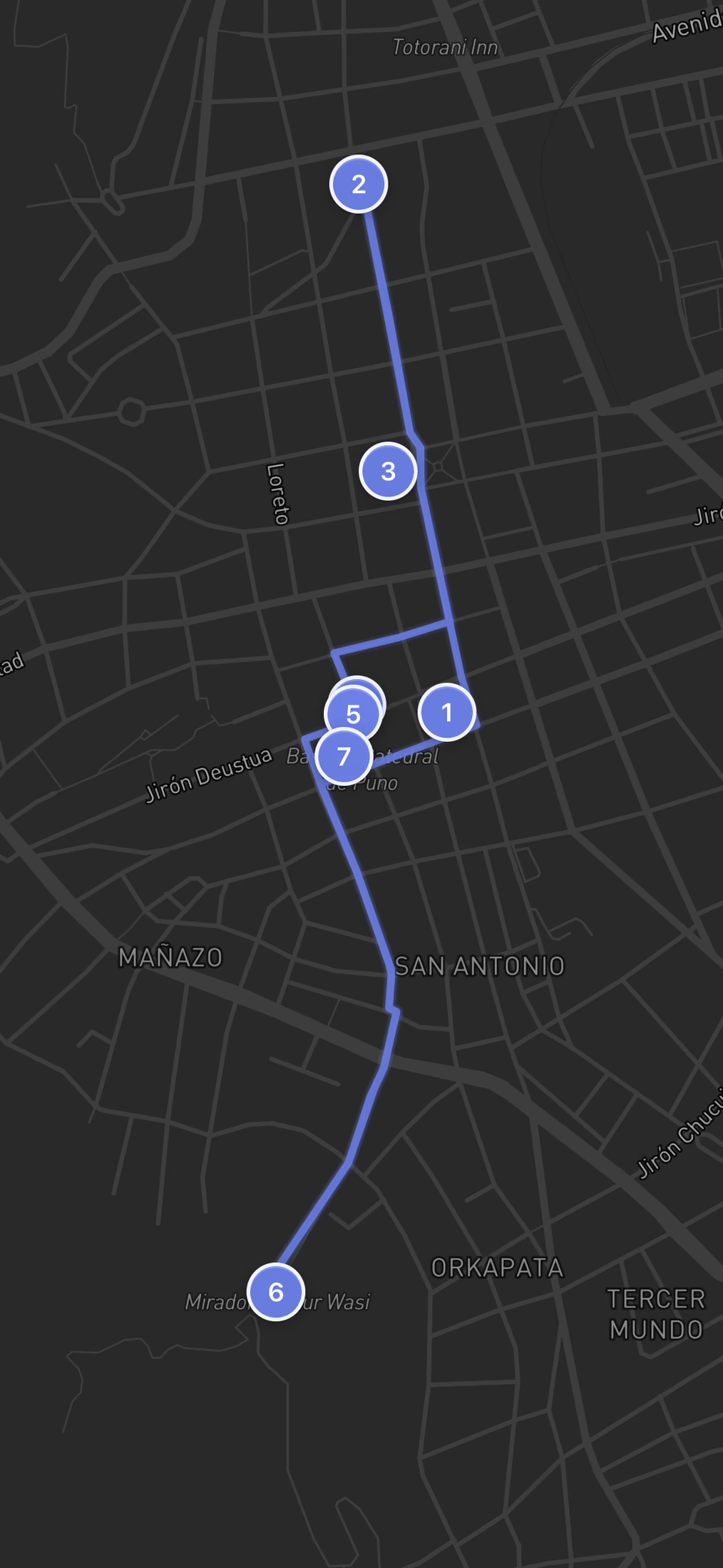
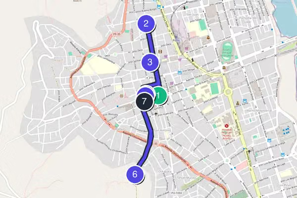
Route typeA gentle horseshoe loop, not a straight line. You climb north out of the plaza to the arch and church, drop back to the museum cluster, push south and uphill to the condor mirador, then descend north to finish at the cathedral back on the plaza.
Realistic timeAbout 2 to 3 hours all in. Pure walking is only 45 minutes across 3.2 km, but the climb to the mirador and the altitude will slow you well past the distance on the map, and the museum eats an hour.
DifficultyShort but not effortless. The center is flat cobble and pavement, easy going, but the stretch up to the Kuntur Wasi viewpoint is a long stone stairway. The real challenge is the thin air at 3,850 meters, so climb it slowly and rest without shame.
Cost to followFollowing the route costs nothing. Six of the seven stops are free public squares, churches, monuments and viewpoints. The only paid stop is the Museo Carlos Dreyer at S/15 for foreigners (S/10 for students with an ISIC card).
Best for:

First-time visitors acclimatizing to the altitude who want to see the real historic center on foot before spending a morning on the lake, rather than being bused between two photo stops.

The Route

Free Walking Tour Map of Puno

7 stops3.2 kmabout 2 hours
Loading the interactive map…The complete walking route will appear here.
Want the route to guide you while you walk?Open the route with navigation and a personal guide for the history, stories and questions that matter to you.
Open route + AI guide

The 7 stops along this route

  1. Plaza de Armas de Puno (Plaza Mayor de Puno) in Puno, stop 1 on the self-guided walking tour
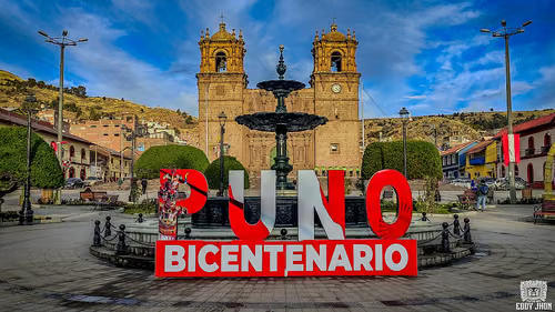
    1Plaza de Armas de Puno (Plaza Mayor de Puno)
  2. Arco Deústua (Arco Deustua, conjunto y glorieta de Puno) in Puno, stop 2 on the self-guided walking tour
    2Arco Deústua (Arco Deustua, conjunto y glorieta de Puno)
  3. San Juan Bautista, Puno (Iglesia de San Juan Bautista) in Puno, stop 3 on the self-guided walking tour
    3San Juan Bautista, Puno (Iglesia de San Juan Bautista)
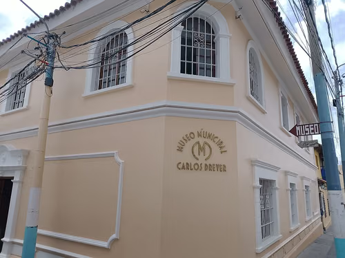
  4. Carlos Dreyer Museum (Museo Carlos Dreyer) in Puno, stop 4 on the self-guided walking tour
    4Carlos Dreyer Museum (Museo Carlos Dreyer)
  5. Missing required field: waypoints[4].image
    5Balcón del Conde de Lemos
  6. Missing required field: waypoints[5].image
    6Mirador de Kuntur Wasi
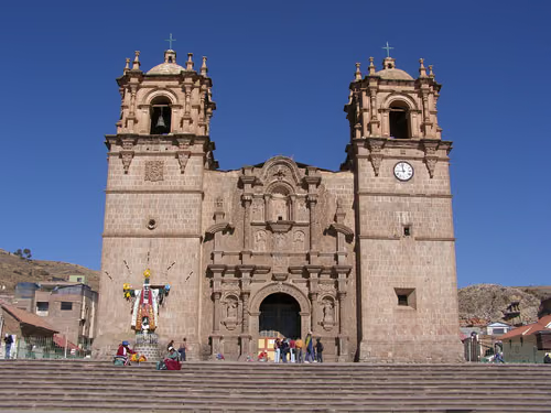
  7. Puno Cathedral (Catedral de Puno) in Puno, stop 7 on the self-guided walking tour
    7Puno Cathedral (Catedral de Puno)
  8. That's the complete route.

    If you want more than the map and text, add live navigation and a conversational AI guide while you walk.

    Open route + AI guide
    You made it
Stop 1 of 7
Swipe →

Your Puno Walking Tour, Stop by Stop

  1. 1

    Plaza de Armas de Puno (Plaza Mayor de Puno)

    Plaza de Armas de Puno (Plaza Mayor de Puno) in Puno, stop 1 on the self-guided walking tour

    Start here because everything else radiates out from it. The Plaza de Armas is the civic center, open day and night and free, fronted by colonial arcades and the cathedral on its south side. It is where the town gathers, where the buses of festival dancers form up in February, and where you will get your bearings before the climbing starts. Take a few minutes on a bench to let your lungs adjust to the altitude. There is no ticket desk, no gate, nothing to pay. Look up the slope to the north and you can already see the stone arch you are about to reach. The square doubles as the meeting point for the boats and tours, so it is busy in the morning. Walk to the northwest corner and head up Jirón Independencia, the pedestrian-leaning street that climbs gently toward the Arco Deústua.
    Hours
    Open 24/7
    Price
    Free (public square, no ticket desk, deterministic shortcut)
  2. 2

    Arco Deústua (Arco Deustua, conjunto y glorieta de Puno)

    Arco Deústua (Arco Deustua, conjunto y glorieta de Puno) in Puno, stop 2 on the self-guided walking tour

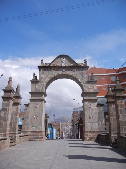
    The stone arch comes into view as the street rises, a triumphal gateway standing alone on the slope above the center. It was raised to the heroes of Peru's independence, and it is one of the cleaner photo spots in town because it frames the streets dropping back down toward the lake. Free, open all hours, no ticket. This is also your first real altitude test: by the time you reach it you will feel the climb in your chest, so pause here without shame. Locals use the arch as a landmark and a backdrop for wedding photos, so mornings are quieter than late afternoons. Stand on the downhill side and shoot back through the arch toward the rooftops for the best frame. From here, walk back down and over a couple of blocks to find the white facade of San Juan Bautista on Jirón Lima, the shrine church that holds the town's patron.

    Hours
    Open 24/7
    Price
    Free
  3. 3

    San Juan Bautista, Puno (Iglesia de San Juan Bautista)

    San Juan Bautista, Puno (Iglesia de San Juan Bautista) in Puno, stop 3 on the self-guided walking tour

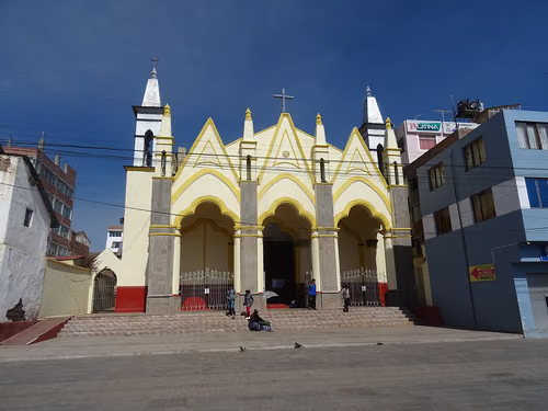
    After the open air of the arch, this church feels like the spiritual core of Puno. San Juan Bautista guards the image of the Virgen de la Candelaria, the town's patroness, and in 1988 the bishop raised the building to the status of a sanctuary dedicated to her. The whole town orbits this image every February for the Fiesta de la Candelaria, one of the biggest religious festivals in South America. Entry is free and the church is open daily from roughly 6:00 to 17:00, with Sunday mass from 7:00, so you can usually step inside. Keep your voice down if a service is on. The interior is plainer than the cathedral you will see later, but the devotion around the Virgen is the point, not the architecture. Head back toward the plaza, down Jirón Lima and Jirón Deústua, to reach the Museo Carlos Dreyer just off the square.

    Hours
    Daily approx. 6:00-17:00 (Sunday mass from 7:00)
    Price
    Free
  4. 4

    Carlos Dreyer Museum (Museo Carlos Dreyer)

    Carlos Dreyer Museum (Museo Carlos Dreyer) in Puno, stop 4 on the self-guided walking tour

    This is the one indoor stop worth the price on the whole walk, and the only one with an admission fee, so plan for it. The museum sits in the old house of Carlos Dreyer, a German collector and artist, and holds about 1,800 pieces spanning pre-Inca, Inca, colonial, and republican Peru. The collection was declared a Cultural Heritage of the Nation in 1980. Inside you move through an Inca hall, a lithic gallery on the Pukara culture, a room on the death cult of the altiplano with objects found at Sillustani, and Dreyer's own painting collection. Entry is S/15 for foreigners, or S/10 for students with an ISIC card. Note the hours: open Monday to Friday 9:00 to 18:00, closed Saturday and Sunday, so a weekend visit means a locked door. Give it 45 minutes to an hour. From the museum, it is a one-minute step toward the cathedral corner to find the carved colonial balcony.

    Hours
    Mon-Fri: 9:00 AM – 6:00 PM | Sat-Sun: Closed
    Price
    S/15 (foreigners; S/10 students with ISIC)
  5. 5

    Balcón del Conde de Lemos

    Missing required field: waypoints[4].image

    Steps from the cathedral, on the corner, is the carved colonial balcony tied to the viceroy known as the Conde de Lemos, who is said to have lodged here. It is a street-level landmark, free to look at, and you take it in from the sidewalk in two minutes rather than touring an interior. The carved wooden balcony is the kind of detail most people walk straight past on their way to the boats, which is the reason to point your eyes up and actually see it. The building keeps daytime visiting hours of roughly 8:00 to 12:00 and 14:00 to 16:00 if anything inside is open, but the balcony itself is just there on the corner whenever you pass. This is your breather before the hardest part of the day. From here, head uphill and to the south toward the stairway that climbs to the condor viewpoint, following the signs and the rising streets toward Kuntur Wasi.

  6. 6

    Mirador de Kuntur Wasi

    Missing required field: waypoints[5].image

    This is the climb everyone warns you about, and they are right. The condor viewpoint sits above town at around 3,850 meters and you reach it by a long stairway, so take it in stages and stop when your heart tells you to. There is no fee and no closing time. At the top a large condor sculpture spreads its wings over the bay, and the payoff is the full panoramic sweep of Puno's red rooftops dropping down to Lake Titicaca, the highest navigable lake in the world. On a clear day you can trace the bay out toward the reed beds where the Uros floating islands sit. This is the visual high point of the walk, literally and otherwise. Go in late afternoon for soft light on the water, but leave yourself time to get down before dark. Face northeast over the lake for the photo. When you are ready, take the stairs back down toward the center and aim for the cathedral on the plaza to finish.

  7. 7

    Puno Cathedral (Catedral de Puno)

    Puno Cathedral (Catedral de Puno) in Puno, stop 7 on the self-guided walking tour

    You finish back where you started, on the plaza, at the cathedral that anchors the south side of the square. This is the right place to end because it is all downhill from the mirador and you arrive with the day's climbing behind you. The granite facade is mestizo baroque, carved in the 18th century by indigenous stonemasons, and the building was declared a Cultural Heritage of the Nation in 1972. Its full name is the Basilica Cathedral of San Carlos Borromeo. Entry is free, but the doors follow mass hours and close around midday for lunch, so aim for roughly 7:00 to 11:30 or 15:00 to 19:00 if you want to step inside. The interior is more restrained than the carved exterior suggests. Stand back across the plaza to take in the full stone facade, then you are done, right next to the cafes and the spot where the morning boats to the islands depart.

    Hours
    Daily, during mass hours (closes midday for lunch) — approx. 7:00-11:30, 15:00-19:00
    Price
    Free

How Long Does This Walking Tour Really Take?

Plan on 2 to 3 hours, which is deliberately generous for a 3.2 km walk. The Museo Carlos Dreyer takes 45 minutes to an hour, the mirador deserves a proper pause at the top to catch your breath and watch the light on Lake Titicaca, and the altitude adds time to every uphill block whether you like it or not.

Budget two to three hours for the full loop, and that is generous on purpose because of the altitude. The walking itself is only about 3.2 kilometers, but the climb to the Mirador de Kuntur Wasi and the stairs back down will slow you more than the distance suggests, especially in your first day or two at 3,850 meters. Do not rush it.

The Museo Carlos Dreyer is where you will spend the most stationary time, around 45 minutes to an hour, and it is the only stop with fixed weekday-only hours, so build the rest of your day around it being open Monday to Friday. The mirador deserves a proper pause at the top, not just a quick photo, so factor in time to catch your breath and watch the light on the lake. For a real break, stop at one of the cafes on the Plaza de Armas before you start the climb, or sit on a bench in the plaza itself. There is no shame in resting twice on this route. Locals do.

Full Route, Shorter Walk or Two-Day Version?

The full loop is only 3.2 km, so most people do it in one go, but the climb to the mirador and the museum's weekday-only hours are the two things that shape how you split it. Here are three ways to walk it depending on your legs, your time, and the altitude.

The Easy Center

Historic core without the big climb

Stops 1–5 then 7, about 1 to 1.5 hours, skipping the mirador

If the altitude is hitting hard, cut the 800 m climb to the Mirador de Kuntur Wasi (stop 6). Walk the plaza, arch, both churches, the museum and the colonial balcony, then head straight to the cathedral. You lose the lake panorama but keep every historic building and stay almost entirely on the flat.

The Two-Part Day

Split around the museum and the boats

Stops 1–5 as a morning, stops 6–7 as a late afternoon, over one day

Best if you're also doing a lake tour. Walk the flat center and the museum (stops 1–5) on a weekday, when the Museo Carlos Dreyer is open, then break for the boats or lunch. Come back late afternoon for the climb to the Kuntur Wasi mirador and the cathedral, catching golden hour on the water.

You can walk it backwards from the cathedral, but the given direction is the smarter one: it front-loads the uphill sections while your legs are fresh, then lets you coast downhill from the mirador to finish on the plaza right by the cafes and the morning boat departures.

Is This Puno Walking Tour Right for You?

This is a short, altitude-heavy loop through a compact historic center, with one real climb and one paid museum. It suits some travelers better than others, so here's who it's for and how to bend it to your day.

A good fit if you…

  • First-time visitors acclimatizing, since the center is flat and you can rest on plaza benches between stops
  • Travelers using Puno as a Lake Titicaca base who want the town itself, not just the port
  • Anyone who wants the condor viewpoint panorama over the red rooftops and the lake
  • People who prefer walking a small center themselves over paying a guide to cross a two-minute plaza

Adapt the route if you…

  • The altitude is hitting you hard: cut stop 6, the 800 m mirador climb, and keep to the flat center
  • It's a weekend: the Museo Carlos Dreyer (stop 4) is closed Saturday and Sunday, so skip it or come back on a weekday
  • You want the best light: start mid to late afternoon so you reach the mirador for golden hour on the water
  • It's raining hard: postpone the mirador, since the stone stairway gets slippery and the view vanishes into cloud

Tickets & Skip-the-Line in Puno

Puno's old center is almost entirely free and open to the street, so there is no queue to beat. Only one stop on this route charges admission, and one has fixed hours that decide when you can go inside. Here is what to know before you set out.

Carlos Dreyer Museum (Museo Carlos Dreyer)The only paid stop on the walk: S/15 for foreigners, or S/10 for students with an ISIC card. Open Monday to Friday 9:00 AM to 6:00 PM and closed Saturday and Sunday, so a weekend visit means a locked door. Give it 45 minutes to an hour and use it as your rain shelter and reliable restroom on the route.
San Juan Bautista, Puno (Iglesia de San Juan Bautista)Free to enter, open daily from roughly 6:00 AM to 5:00 PM, with Sunday mass from 7:00. Keep your voice down if a service is on.
Puno Cathedral (Catedral de Puno)Free, but the doors follow mass hours and close around midday for lunch. Aim for roughly 7:00 to 11:30 AM or 3:00 to 7:00 PM if you want to step inside.
Balcón del Conde de LemosFree street-level landmark you take in from the sidewalk. If anything inside is open, daytime visiting hours run roughly 8:00 AM to 12:00 PM and 2:00 to 4:00 PM, but the carved balcony is on the corner whenever you pass.
Everything elseThe Plaza de Armas, the Arco Deústua and the Mirador de Kuntur Wasi are free open-air public spaces with no ticket desk and no closing time. Just walk up.
Optional upgrade
+3
The same 7-stop route,
now with navigation and a guide.
Optional AI experience

You already have the route.
The AI guide brings it to life.

Standing on the Plaza de Armas with the cathedral in front of you and not sure which way is up to the arch? Let the AI guide walk you through it. It talks you stop to stop, from the plaza up to the condor mirador and back, telling you what you are looking at and where to turn next, while you keep your eyes on Puno and Lake Titicaca instead of a map.

Livenavigation13languagesAnyquestionYourinterests
Open this route with the AI guide

Try it in your browser · No app or download required

Tips for Walking in Puno

  • Timing: do this walk in the morning if you also want a lake boat tour, since most boats to the Uros islands leave the Puno port early. Better still, walk the center on a Monday-to-Friday afternoon so the Museo Carlos Dreyer (9:00-18:00, closed weekends) is open, then save the lake for the next morning.
  • Terrain and shoes: the center is flat cobble and pavement, but the stretch up to the Mirador de Kuntur Wasi is a long stone stairway. Wear shoes with grip, not flip-flops. The real challenge is not the surface, it is the altitude at about 3,850 meters, so pace the climb slowly.
  • Restrooms: the Museo Carlos Dreyer is your most reliable stop for a clean bathroom on this route, since it is an indoor paid attraction. Use it while you are inside. Public toilets in the plaza area are scarce, so the cafes around the square are your backup.
  • Food and drink: grab a coca tea (mate de coca) at a cafe on the Plaza de Armas before the climb. It is the standard local remedy for the altitude, cheap, and it genuinely helps. Have it warm before you head up to the mirador, not after.
  • Photo: the best shot is from the top of the Mirador de Kuntur Wasi, facing northeast over the red rooftops toward Lake Titicaca. Go in late afternoon for soft light on the water, and start the climb early enough to be back down before dark.

Why Walk This Route?

Puno sits at about 3,850 meters on the shore of Lake Titicaca, the highest navigable lake in the world at an average altitude of 3,812 meters. Most people treat the town as a one-night stop before the boats to the Uros floating islands and Taquile, and they miss what is actually here. The old center is small, walkable, and almost entirely flat until you decide to climb, which is exactly why a tour on foot beats a taxi or a half-day group bus that drops you at two photo spots and leaves.

This route is short on paper, about 3.2 kilometers, but it earns its time because of the altitude. You will be breathing hard on the uphill sections, and that is normal. The walk strings together the plaza, two churches, the town's best museum, a colonial balcony, a triumphal arch, and a viewpoint that hangs over the whole bay. It works because everything connects: you climb out of the plaza, hit the monuments on the rise, loop up to the condor mirador for the lake panorama, then drop back down to the cathedral to finish.

Do it in the right order and you front-load the climbing while your legs are fresh, then coast downhill at the end. Skip the order and you will be hauling yourself up to the mirador after the museum has already worn you out. Take it slow. This is not a city you power-walk through.

Common Questions

Is Puno safe to walk around?

The historic center around the Plaza de Armas, the cathedral, and Jirón Lima is fine to walk in daytime, and that is where this whole route stays. Use normal city sense: keep your bag in front in crowds, do not flash a phone or camera in quiet streets, and be more cautious after dark, especially on the stairs up to the Mirador de Kuntur Wasi, which empties out at night. Around the plaza and the port you will be approached by people selling boat tours to the Uros islands. They are not dangerous, just persistent. Compare a few prices before booking rather than taking the first quote, and be wary of anyone rushing you to pay cash on the spot.

What if it rains during my Puno tour?

The rainy season runs through the southern summer, so afternoon showers are common. The one indoor stop on this route is the Museo Carlos Dreyer, so duck in there and give the collection the full hour while it passes. The cathedral and San Juan Bautista are also covered, free, and good places to wait out a downpour during their open hours. The one stop to postpone in heavy rain is the Mirador de Kuntur Wasi, because the stone stairway gets slippery and the lake view disappears into cloud. Save the climb for a clear window.

What's the best time of day for this walking tour?

Start mid to late afternoon if your main goal is the view. That way you climb to the Mirador de Kuntur Wasi when the light is softening on Lake Titicaca, which is the best photo of the day. The catch is the Museo Carlos Dreyer closes at 18:00 and is shut on weekends, so on a weekday hit the museum first in the afternoon, then finish at the mirador for golden hour. If you also want a boat to the islands, do the town walk in the afternoon and keep your morning free for the lake.

Take this route with you

Open this exact tour with navigation and your personal AI guide.

Start GPS Navigation + AI Guide
AI Tourguide
Researched and curated by the AI Tourguide teamWe plan and quality-check every route, then research and verify the opening hours, prices, and practical tips for each stop along it.
▶ Open route with AI guideNavigation, stories and your questions